


Intelligence Gathering
The success of the operation would depend on accurate and detailed topographical information about the beaches and coastal towns along the French coast. Aerial photographs helped identify likely locations but, to obtain more detailed views, the Government appealed to the public for holiday photographs and postcards of unspecified coastal areas of France. However much more detailed information on the target beaches and their approaches was required. Local conditions such as the composition of the beaches, hidden underwater banks, German defensive obstacles, depth of water, tidal conditions etc would all be taken into account in the planning of the project. The stakes were very high - bad intelligence could jeopardise the whole vast project.... there was no room for error.
On New Year's eve 1943, under the leadership of 24-year-old Major Logan Scott Bowden of the Royal Engineers, a unit set out in motor torpedo boats to reconnoitre the area around Luc-sur-Mer. They transferred to a hydrographical survey craft and moved closer to shore before Major Logan and Sgt Bruce Ogden-Smith swam to the beaches where they took samples of sand, mud, peat and gravel which they stored in labelled tubes. They were careful not to leave behind any evidence of their visit lest the Germans became alerted to their clandestine activities - much of their lateral movement along the beaches was below the tidemark! Their mission was a total success.
A month or so later, this time using a midget submarine for transport (towed part of the way), the area to the west of Port-en-Bessin and Vierville was visited and a few weeks later the Omaha beach area. Two scale models of the landing beaches were prepared using all the information gathered. One was held by the War Department in room 474 of the Great Metropole Hotel in London and a duplicate in the Prime Minister's room in the War Cabinet Offices - two of the most secret rooms in the country.
At Cairnryan, just north of Stranraer in southwest Scotland, the information gathered about the beaches was used to construct a "life size" reproduction of the beaches. This would allow the planners to assess the effectiveness of the current landing techniques and the movement of men and machinery over the terrain. To-day Cairnryan and Stranraer comprise the main Ferry links from Scotland to Ireland and many of the old wartime relicts can still be seen on the shores of Loch Ryan.
The Manufacturing Process
The scale of the project was enormous and was in danger of over-stretching the capacity of the UK's civil engineering industry. From late summer of 1943 onwards three hundred firms were recruited from around the country employing 40,000 to 45,000 personnel at the peak. Men from trades and backgrounds not associated with the construction industry were drafted in and given crash courses appropriate to their work. Their task was to construct 212 caissons ranging from 1672 tons to 6044 tons, 23 pier-heads and 10 miles of floating roadway. Most of the concrete caissons were manufactured on the River Thames and the River Clyde in some cases using hastily constructed dry docks. The steel "Beetle" floats were assembled in Richborough, Kent, the concrete Beetles at Southsea, Marchward and Southampton and the pier-heads and buffer ramps at the Morfa site Hughes had used for the manufacture of his Hippo caissons. Trials continued to be run in the Garlieston area of the Solway, even during the manufacturing phase, on for example, the buffers.
Hughes involvement continued throughout the manufacturing period and beyond. He helped identify Selsey and Dungeness on the south coast of England as ideal places to "park" the completed caissons until needed. There were tensions between the War Office and the Admiralty, which sometimes resulted in poor co-operation and bad communications. After earlier allocations of responsibility had failed to resolve matters the War Office was tasked to design the caissons and oversee the development of the pier-heads and piers while the Admiralty were tasked to design and oversee the development of the floating breakwaters. This agreement was later refined to take account of continued Admiralty concerns about the berthing and navigation guides and it was therefore agreed that they would be responsible for the towing all the components across the channel, the layout and positioning of the harbours and the navigational channels and moorings.
D-Day +
A large number of British and USA tugs were requisitioned to tow the Mulberries from their assembly point near Lee-on-Solent to France. Operation Corncob got underway when the first of the tugs set off on June 4 later to hold their position in mid channel when D-Day was delayed by a day. When the invasion finally got underway most caissons were positioned about 5 miles off the French coast. Responsibility for Mulberry B off Aromanches fell to the No 1 Port Construction and Repair Group. They received orders to sail on June 6 1944 (pm) and by the early hours of June 7, under the command of Lt Col Mais, markers were in place at high tide level and on higher ground, for alignment purposes, for the first two piers. Elsewhere further out to sea marker buoys for the caissons and block ships were positioned under the command of Lt Cdr Landsdowne of the RN. This done the blockships slipped their moorings in Poole harbour and sailed for France on their final voyages. Scuttling them in pre-determined 'overlapping' positions was a tricky operation but essential to ensure effective protection against high seas and fast flowing tides. Similar operations were in progress at Mulberry A off Vierville-Saint-Laurent but here the vessels came under heavy enemy fire. The tugs, which had accompanied the vessels, and which were to assist in their final positioning, dispersed earlier than planned. By a stroke of good fortune the 2nd and 3rd block-ships were sunk by the Germans in roughly the correct positions. In all 5 Gooseberries were positioned to provide the best protection for the two Mulberry harbours and for other beach landing points at Utah, Courseulles, 11k east of Arromanche, and Ouistreham. These breakwaters provided a good measure of protection during and after the construction of the 2 Mulberry harbours and in the other beach locations. The UTAH beach was a major logistical supply base for the Americans up to November '44 thanks to the protection afforded by its 'Goosberry.' The Bombardons were towed out on June 6 to their moorings, which had been laid previously by boom laying craft. However a mistaken order resulted in the Bombardons being placed in water some 20m to 24m deep rather than the designed 13m and they were strung out in a single line when there should have been a double line. The effectiveness of this outer barrier had been compromised.
On D+1 the caissons, each with a 4 man crew, two sailors and an anti-aircraft gun emplacement, were towed to positions about a mile off-shore and handed over to a fleet of powerful harbour tugs which manoeuvred them into their final positions. The caissons' sea valves were opened until they settled at previously agreed depths. Each Mulberry was about a mile long and stood about 30 ft (9m) above sea level at low tide and 10 ft (3m) at high tide. The block-ships at Mulberry B were all in position by June 13th and formed two crescent shaped harbours, which accommodated 75 Liberty ships and small craft. The installation of the stores and LST piers proved to be more of a problem. The tows began to arrive at Mulberry B on D+4 and work continued throughout the night. Choppy seas made the manoeuvring of the bridging spans very difficult. By D+8 the stores pier and roadway amounting to 1.2k was in place and operational. The 2nd stores pier was operational by July 8. It was later discovered that the Beetle floats to support the roadway had been positioned in an alternate pattern rather than opposite each other as the design intended. This proved to be a costly error when consequential stability problems were experienced. The Luftwaffe attacked Mulberry B on July 15 but such were the defences that 9 of the 12 Messcherschmitts were shot down. Mulberry A was in use for less than 10 days when it was severely damaged by the worst period of sustained severe weather for 40 years. Out of 31 caissons laid in position 21 were damaged beyond repair with broken backs and sides. Mulberry A was never used again and parts of it were scavenged to repair damage to Mulberry B.
The Americans quickly reverted to the traditional methods of unloading from landing craft and DUKWs directly onto the beaches often coming in on one tide and leaving on the next. Such was their success that on occasions they exceeded the impressive performance achieved at Mulberry B. Each day around 9000 tons were landed via Mulberry B until the end of August by which time Cherbourg port became available for use at least in part and, towards the end of the year, after the capture of Walchern, the port of Antwerp. Mulberry B was in use for 5 months during which time over 2 million men, half a million vehicles and 4 million tons of supplies passed through the harbour. During this period several additional caissons where used to reinforce weak points in the breakwater. The Mulberry project was for certain a great feat of engineering - a highly complex task completed in just 6 months of manufacture, by hundreds of contractors in dozens of locations, under wartime conditions and a serious shortage of skilled labour. The planners were heavily influenced by the paramount need to secure the Allied supply line since the invasion would otherwise stall and collapse as the enemy regrouped and drew on their reserves. There are those who believe that Mulberry was unnecessary as exampled by the Americans success in landing supplies directly onto the beaches after the abandonment of Mulberry A. We'll never know, with any degree of certainty, what would have happened had Mulberry never been built... and that for many is all the justification needed for the planners' decision to authorise the project. With the exception of those who were there in the summer of 1944, I can find nothing similar that allows one to imagine the vastness of the operation and the absolute necessity to move men, supplies, munitions and equipment to the right place at the right time. Even the logistics faced by the largest supermarket chains today pale into insignificance when compared to the task faced by the planners in the early 1940s.
They faced an awesome responsibility and the wider world faced dire consequences in the event of failure to deliver. The Supermarket scenario offers an opportunity to put the scale of the task into a modern context. It has been calculated that each serviceman needed 6.5lb (3Kg) per day to sustain him in the field. On this basis1000 men needed around 2.5 tons, 100,000 needed 250 tons and 1,000,000 2,500 tons per day!. As the size of the invading force grew so did the daily demand for supplies. Then there were the lorries, tanks, artillery pieces, ammunition, military field hospitals, mobile radar and communications units etc etc. all of which had to be transported across the channel. Over 4,000 vessels plied the waters between the UK and Normandy from D-Day and the contribution of Mulberry B in speeding up the operation and securing the supply chain in adverse weather conditions, is beyond question. The majority of vessels in use were not capable of beach landings. After the war at the Nuremberg trials, Albert Speer gave the enemy perspective on the Mulberry Harbours and their Atlantic Wall defences. 'To construct our defences we had in two years used some 13 million cubic meters of concrete and 1.5 million tons of steel. A fortnight after the landings by the enemy, this costly effort was brought to nothing because of an idea of simple genius. As we know now, the invasion forces brought their own harbours, and built, at Arromanches and Omaha, on unprotected coast, the necessary landing ramps."
The following photographs are of Aromanches today, the top one looking east and the bottom one looking west. Both are by courtesy of Nigel Stewart
To conclude, let me tell you about the village of Garlieston which was highlighted throughout the above article. Garlieston is a small port on the east coast of The Machars in the former county of Wigtownshire with its origins dating back to the 1780s when Lord Garlies planned and built a small port on the sheltered shores of what later became known as Garlieston Bay. By 1800 Garlieston had grown to become home to 500 people and port to 10 trading vessels. A pier was built to expand the harbour’s capacity in 1816. Local industry expanded to include the production of sailcloth and ropes, and shipbuilding also took place. At the start of the 1900s Garlieston Harbour’s rail connection meant that special excursions could arrive on the quayside, allowing passengers easy access to steamers bound for the Isle of Man. However, the railway closed in 1950, but the excursions to the Isle of Man had already ceased in the 1930s. In more recent years Garlieston has become less significant as a commercial port but it remains an important centre for yachting and other leisure craft and today the village’s main role is as a resort and to this end the area between the south of the village and the harbour now has an attractive and conveniently located Caravan Club site. In addition you will find an excellent exhibition entitled “GARLIESTON’S SECRET WAR”. The exhibition is in its second year and runs from 10 April – September 30th 2004 in the Forteviot Hall, Garlieston. It will be running again in 2005, but the organisers hope to have a more permanent location for the exhibition than the local Church Hall used for the exhibition at the moment. The exhibition includes photographs and commentary highlighting Garlieston’s role in the Mulberry Harbour development. It includes an excellent model of a Mulberry harbour and there is also a video presentation featuring the Mulberry Harbours and D-Day together with books and souvenirs for sale. Admission is £2 for adults (children and concessions £1.50) or family £4. So the next time any members are thinking of a visit to Scotland, or indeed already reside within Scotland, why not take that turning off the M74 at Gretna Green and head West to discover more of Scotland’s best-kept secrets.
The success of the operation would depend on accurate and detailed topographical information about the beaches and coastal towns along the French coast. Aerial photographs helped identify likely locations but, to obtain more detailed views, the Government appealed to the public for holiday photographs and postcards of unspecified coastal areas of France. However much more detailed information on the target beaches and their approaches was required. Local conditions such as the composition of the beaches, hidden underwater banks, German defensive obstacles, depth of water, tidal conditions etc would all be taken into account in the planning of the project. The stakes were very high -
The Manufacturing Process
The scale of the project was enormous and was in danger of over-
D-
The following photographs are of Aromanches today, the top one looking east and the bottom one looking west. Both are by courtesy of Nigel Stewart
To conclude, let me tell you about the village of Garlieston which was highlighted throughout the above article. Garlieston is a small port on the east coast of The Machars in the former county of Wigtownshire with its origins dating back to the 1780s when Lord Garlies planned and built a small port on the sheltered shores of what later became known as Garlieston Bay. By 1800 Garlieston had grown to become home to 500 people and port to 10 trading vessels. A pier was built to expand the harbour’s capacity in 1816. Local industry expanded to include the production of sailcloth and ropes, and shipbuilding also took place. At the start of the 1900s Garlieston Harbour’s rail connection meant that special excursions could arrive on the quayside, allowing passengers easy access to steamers bound for the Isle of Man. However, the railway closed in 1950, but the excursions to the Isle of Man had already ceased in the 1930s. In more recent years Garlieston has become less significant as a commercial port but it remains an important centre for yachting and other leisure craft and today the village’s main role is as a resort and to this end the area between the south of the village and the harbour now has an attractive and conveniently located Caravan Club site. In addition you will find an excellent exhibition entitled “GARLIESTON’S SECRET WAR”. The exhibition is in its second year and runs from 10 April – September 30th 2004 in the Forteviot Hall, Garlieston. It will be running again in 2005, but the organisers hope to have a more permanent location for the exhibition than the local Church Hall used for the exhibition at the moment. The exhibition includes photographs and commentary highlighting Garlieston’s role in the Mulberry Harbour development. It includes an excellent model of a Mulberry harbour and there is also a video presentation featuring the Mulberry Harbours and D-
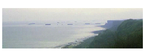
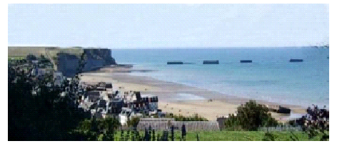
Aromanches today looking East (above) and West (below)